Sprint Prologue : typical campus sprint terrain, with buildings, passageways and stairs. Limited or no multi-level running
Day 1 Middle Distance : spur-gully terrain with some steeper areas. Vegetation is generally open, allowing fast running but there are significant areas of slower running (and walk) along watercourses. Lots of termite mounds but very few tracks.
Day 2 Long Distance : classic spur-gully with many intersecting gullies and some seriously steep areas. Slower run in areas of green, particularly along watercourses. Many termite mounds but few tracks.
Day 3 Middle Distance : open spur gully terrain combined with unusual sandstone/conglomerate pagoda-style rock formations featuring many high cliffs. Some steeper areas and slower run in heavier vegetation.
previous maps
Previous Maps will be available on Eventor and the website closer to the events.
embargoes
Several areas are currently under embargo and may not be entered by anyone intending to compete in or attend any of the 2027 Australian 3-Days events.
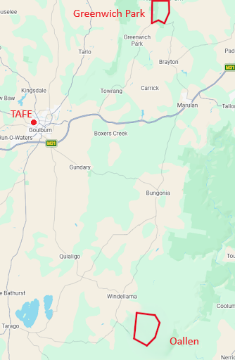
This includes the area in and around Goulburn TAFE campus and the private property of Timberlight (Oallen), and the private properties on the orienteering map known as Yuruga (Greenwich Park) shown broadly by red outlines on the map below.
Entry onto these areas by Orienteers is not permitted, nor is the carrying and use of maps, photography or attempts to survey the terrain.